
GIS SERVICES
1. Utility Network data capturing
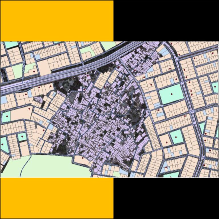
• Utility Network GIS data capture is a technique in which the information on various map attributes, facilities, assets, and organizational data are digitized and organized on a target GIS system in appropriate layers.
• GIS Data capture can be divided into:
1. Primary GIS Data Capture Techniques:- The primary GIS data capture techniques use remote sensing and surveying technologies to capture the data using either raster data capture or vector data capture.
2. Secondary GIS Data Capture Techniques:- The secondary GIS data capture technique use technologies such as scanning, manual digitizing, vectorization, photogrammetry.
• GIS Data capture services provided by hantech can used for: 1. Thematic Maps Creation: Analyzing practical regional / cultural issues, transportation facilitation, hydrographic mapping, vegetation and other types of related features
2. Capturing Electrical power networks using special software for GIS data capture
3. Capturing Navigation data for easy navigation
4. Capturing Land records and survey data for property, land, water and holding tax, etc. The spatial features are extracted from Ariel imagery using photogrammetry methods.
5 .Creation of Utility infrastructure GIS data capture for water lines, road network, pavements, sewerage network, and other related features
• Our Team has Extensive Knowledge and Experienced and dedicated team for Utility Network Data capturing Work
2. Topographic Map (Zoming & Contouring )
• Topographic maps, also known as topo maps, typicallydisplay elevation characteristics, natural and structural features as well as hydrography and infrastructure data in a
large-scale format.
• Topographic maps provide a third dimension to an otherwise flat map. Topo maps are used for a range of applications, from geographic research studies to environmental impact assessments for commercial and residential development
3. Zoning MEP (Digitization )
• The official zoning map is a legal document maintained by the Planning and Development Department that defines the zoning for all areas within the City’s jurisdiction. Every parcel of land within the City’s jurisdiction, including parkland, has a zoning designation. The spatial designations in the official zoning map are known as zoning districts.
• IMAPS is very similar to other interactive online maps that allow you to search for addresses, measure distances, or look at satellite images. What makes iMAPS special is that it also gives you access to Wake County’s tax data and a wide range of regulatory and policy information from the City of Raleigh, including the Official Zoning Map
.• Our Team has Extensive Knowledge and Experienced and dedicated team for Zoning Map ( Digitization )
4.Geological MEP ( Digitization )
• Digital geologic mapping is the process by which geological features are observed, analyzed, and recorded in the field and displayed in real-time on a computer.
▪ Benefits of Geological MEP ( Digitization)
• Data entered by a geologist may have fewer errors than data transcribed by a data entry clerk.
• Data entry by geologists in the field may take less total time than subsequent data entry in the office, potentially reducing the overall time needed to complete a project.
• The spatial extent of real world objects and their attributes can be entered directly into a database with geographic information system (GIS) capability. Features can be automatically color-coded and symbolized based on set criteria.
• Multiple maps and imagery (geophysical maps, satellite images, orthophotos, etc.) can easily be carried and displayed on-screen.
• Geologists may upload each other’s data files for the next day’s field work as reference.
• Data analysis may start immediately after returning from the field, since the database has already been populated.
• Data can be constrained by dictionaries and dropdown menus to ensure that data are recorded systematically andthat mandatory data are not forgotten
5.Hydrogeological MEP
• Hydrogeologic mapping is a method of gathering and evaluating geological information to create a threedimensional depiction of the subsurface material in which groundwater occurs. By mapping the spatial distribution of geologic material with distinctive permeability, the hydrogeologist can understand which geologic units will allow movement of groundwater and which units will restrict groundwater movement.
6.Ground Cadastral MEP ( Digitisation )
• Digitization of cadastral maps is the process of acquiring vector map from the existing analogue maps. It means source of vector data is the existing analogue maps Therefore source must be clean, clear, unfold, non scratched and non shrinkaged.
• Cadastral maps are age-old maps with village boundary and individual survey numbers prepared by using chain survey.
• These maps provide complete information about the actual property present in the area like land ownership, the extent of land, roads present in the village
• Aerial photogrammetry and high-resolution satellite images clubbed with GPS is revolutionizing the idea of large scale mapping, addressing the mapping problems at the scale of 1:10,000 and larger.
7. Digital Terrain Modeling
Digital terrain model
• A digital terrain model (DTM or DEM) is a three-dimensional representation of the earth’s surface, represented as an array of points with a defined height. The terrain model contains information about the height without considering vegetation, buildings, and other objects.
• WE USING A DIGITAL TERRAIN MODEL FOR THESE
FOLLOWING
1 For mapping purposes to build a digital surface model Forecasting of landscape processes (where water will accumulate, in which place it is better to plant plants, etc.
2 Territorial planning
3 Design of buildings and structures
4 Construction of highways, highways, and interchanges.
5 Environmental problems (including modeling of environmental situations).
6 Building a digital model of the bottom relief of reservoirs.
7 Study and quantitative assessment of the current state of the natural environment.
8 Household use of digital modeling in GIS – electronic maps, navigators.