Airborne Lidar is used to measure land – surface elevation hidden amid the vegetation conopy also by detecting elevation changes between repeat surveys , Lidar has revealed processes our landscapes
we have owning our own aircraft and deploying the most advanced technologies
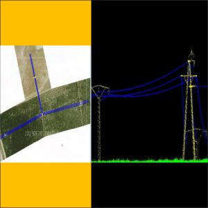
Hantech provide our clients fast, accurate, and high-quality data through our airborne Lidar services. Airborne Lidar provides extraordinary efficiency and speed in gathering accurate spatial data and is integrated with our image sensors to provide simultaneous Lidar and image acquisition