
REMOTE SENSING
1. Auto DEM extraction
• A Auto DEM extraction (DEM) is a regularly spaced raster grid of elevation values of a surface terrain. We use DEMs to produce maps such as contour maps, orthophoto maps, and perspective maps. We also use DEMS for route planning in the construction of highways and railways. In remote sensing, DEMs are used in mapping, orthorectification, and land classification.
• The DEM Extraction Module also supports Digital Point Positioning Data Base (DPPDB) data
• we offer tailored digital elevation modeling, digital surface modeling services for specific industry applications such as urban mapping, forestry, land management and mining.
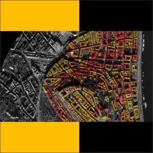
2.Impervious features extraction
• Impervious surfaces and features using certain built-up indices (BUIs) that are developed from space-borne optical and SAR remotely sensed sensors
• impervious surfaces under a spectral mixture analysis model
• we offers a best services in Impervious Features extraction impervious surfaces and features using certain built-up indices (BUIs) that are developed from space-borne optical and SAR remotely sensed sensors.
3. GIS Database creation and integration
• A database over a schema is defined as a set of sets, one for each relation (in a relational database). The database corresponding to the source schema would comprise the set of sets of tuples for each of the heterogeneous data sources and is called the source database.
• Data integration appears with increasing frequency as the volume and the need to share existing data explodes
• Hantech provides GIS Database creation and integration services to its clients in a much faster manner
4. Image classification
• One of the most important functions of remote sensing data is the production of Land Use and Land Cover maps and thus can be managed through a process called image classification.
• Our company provide a best services in Image classification the all three types image classification services provide our experienced and dedicated team on domestic level
• The 3 main types of image classification
1 Unsupervised image classification
2 Supervised image classification
3 Object-based image analysis