
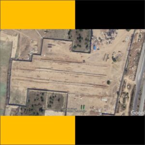
UAV/ Drone aerial mapping
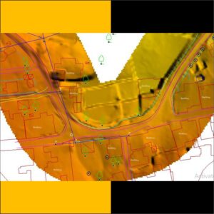
1. Topographic Mapping
• Topographic map is a type of map characterized by large-scale detail and quantitative representation of relief features, usually using contour lines (connecting points of equal elevation).
• Topographic maps have many multiple uses in the present day: any type of geographic planning or largescale architecture; earth sciences and many other geographic disciplines; mining and other earth-based endeavours; civil engineering and recreational uses such as hiking and orienteering.
• Our Topographic Mapping Service can be used for :
1 Civil Engineers (to design civil structures of all kind)
2 Natural resource conservation
3 Energy exploration
4 Environmental issues
5 Emergency and disaster response
6 Planning transportation routes
7 Public Utility planning, etc

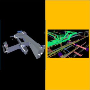
2. Corridor Mapping – Road, Rail, Powerline, Pipeline, Canal
• Corridor Mapping combining two or more raster sets that analyze a least cost path from each cell to a “source” site. Corridor Mapping returns a raster in which the sum of the cost distances (accumulative costs) for each of the input cost rasters is calculated for each cell location.
• Corridor mapping allows Hantech One to fly in a linear pattern in order to achieve faster and more efficient mapping of roads, railways, and pipelines. The corridor area can be automatically extracted from a polyline KML file or it can be manually entered.
• The corridor area is broken into segments according to the change of direction along the linear feature (a bend in the road, pipeline, railway track, etc.)
• Hantech executes the segments sequentially. The number of flight lines is always an odd number to optimize the flight time and to facilitate the transition between
segments. For a narrow corridor, three flight lines provide sufficient data for a successful reconstruction.
3. Mining
• Conduct mining operations with accuracy & gain access to accurate data easily and quickly. Keep track of stockpile volumes, and mining operations and enhance decision making. Real Time Control. Quality Control. Progress Reporting. Surveys & Inspections.
• As part of mine automation, drones can help to achieve many benefits for effective mine planning – conducting initial survey, carrying out exploration activity, physical
terrain mapping for segregation of land use, contour mapping, 3D modeling and terrain modeling. This apart, they can help in reclamation analysis by orthophotography using Light Detection and Ranging (LiDAR).
• We use drones in mining improve the overall efficiency of large mine site and quarry management by providing accurate and comprehensive data detailing site
conditions in a very short time. They also support better coordination among team onsite and, offering dynamic oversight of all operations.
4 .Disaster management
• Disaster management unmanned aerial vehicles (UAVs) are increasingly being used to provide aid in many disaster management operations and help increase the effectiveness of a disaster response.
• UAVs can provide high-resolution, real-time images of even the inaccessible locations. These images can then be used to produce accurate hazard maps so that prevention and mitigation measures for reducing disaster risks
• In a post-disaster situation, UAVs can be used to map the affected areas in high resolution within a short time, which, in turn, can aid swift and efficient response, he said during a national-level brainstorming session on “Application of Unmanned Aerial Vehicles (UAVs) in Disaster Management”
• “UAVs can be effectively used in different phases of disaster management – they can help us identify areas affected by disasters. They can also aid disaster response,
5. Construction Monitoring
• Construction monitoring is a service which provides the client with independent verification (to the extent of the consultant’s engagement) that the works have been completed in accordance with specified requirements
• Our project monitoring services include: Gain regular, accurate project status information on engineering, material delivery, production, inspection, testing, packing and shipping, helping you Make informed decisions
1. Protect your investment and assure quality with constant project monitoring
2.Ensure your project adheres to schedule and can be completed on time and within budget
3.Comply with local and international regulations and quality standards
4.Detect possible problems quickly with regular reporting, helping you foresee cost overruns and delays
5.Evaluate technical solutions to keep the project on track
6.Property Mapping
• Hantech performs house, flat, apartment, floor mapping with high resolution and high accuracy
• Hantech Provides a best services in Property Mapping Our extensive knowledge and experienced team for work in Property mapping
• We provide following all these Services :-
I. Creating an Expression Mapping
II. Deep Mapping
III. Skipping Properties
IV. Converters
V. Providers
VI. Conditional Mapping
7. Agriculture and Forestry
• Hantech Provide best services in agriculture and foresty in Domestic
• we gives following these services in Agriculture :-
1. Irrigation & water shed analysis(स िंचाई और जल शेड सिश्लेषण)
2. Crop damage control analysis (फ ल क्षसि सियिंत्रण सिश्लेषण)
3. Land use land cover mapping (भूसि उपयोग भूसि किर िािसचत्रण)
4. Crop health monitoring (फ ल स्वास्थ्यसिगरािी)
5. Topography surveys (स्थलाकृ सि िेक्षण)
6. Cadastral mapping (भूकर िािसचत्रण)
7. Drone spraying (डर ोि सिड़काि)
• we gives following these services in Foresty :-
I. Forest encroachment
II. Area demarcation (Protected forest, Reserved Forest)
III. Tree Disease detection
IV. Forest Mapping
V. Forest Fire Monitoring and mapping
VI. Tree Disease Mapping